Family Contexturized

Following Us Through the Ages

Family History in Photos

  • Sayles, Frank & Mary
    • Family, All Grown Up
    • Kids – Nancy & Hope
    • Album – Nancy Sayles 6.19.1912
    • News Clippings, Letters & Docs
  • Sayles, Others & Earlier
  • Day – HMD & Other Family
    • Family
    • News, Letters & Docs
  • Day – Garnett & Nancy
    • Nancy & Garnett
    • Family Photos
    • The Children
    • With Friends
    • Greenwich Home
    • Cornwall Days
    • Garnett & Nancy’s Travels
      • Europe with Mother Mary
      • Egypt (1924)
      • Petra
      • Maine?
      • England-Ireland
      • Carribean
    • News, Letters & Docs
      • News Clippings
      • Letters
      • Documents & Awards
  • Day – Garnett
    • Army
    • Around The World ?
    • Collins-Day Expedition 1915-16
  • Day – Nancy
    • Nancy & The Count
    • Art
    • Show Dogs
  • Day – Connie & Peter
    • The Kids
    • With Family
    • Wedding
    • News, Letters, Docs
  • Gillespie, Don & Lee
    • The Early Years
    • Family – Later
    • Family – The Kids Growing Up
    • After the Wedding & Europe
    • Album – The Kids
    • Album – Skiing
    • Building the House in Concord
    • Sailing
    • Abigail Pics
    • News Clippings, Letters, Docs
  • Gillespie, Don
    • Youth
    • Thespian
    • School Daze – Don & Friends
    • Trip – Martha’s Vineyard, Boston, etc
    • Army

Thoughts | Updates

  • 1915 Expedition – Why Boliva?
  • Brief Modern History of the Chapare Region
  • Great Elaenia (Elaenia dayi)
More Posts...

My Recent Activities

Lee's Blog/Website
LGD Photography

1915 Expedition – Why Boliva?

April 8, 2020 by Lee 1 Comment

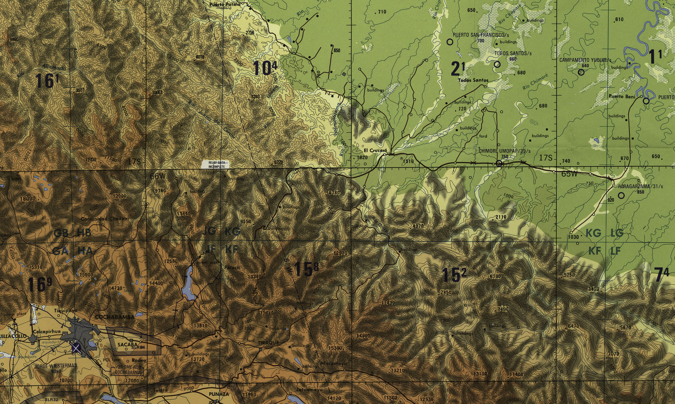
That’s a question I’ve thought about a fair bit. Why head out for this particular remote corner of the world when there were so many untapped frontiers? My thought is that it’s because for Garnett, this was a bit of a known quantity. Remember that the family business was nuts, literally. Brazil Nuts were a specialty of Baker-Bennet-Day Imports, in fact they had the Brazil Nut monopoly for the US until that kind of thing was legislated out of practice. Anyway, it’s likely that Garnett was somewhat familiar with the local logistics which included transport ships sailing into the heart of the Amazon Basin where they were loaded with rubber, coffee, oil, iron, nitrates, as well as other agricultural products. Furthermore, around this time there was a concerted effort to build rail links from the headwater regions of the Amazon over the Andes to the Pacific. One of the proposed routes was in fact through Cochabamba, Bolivia, the stepping off point for the most remote leg of the Collins-Day Expedition. So, I would expect that in the business world this route, down a remote tribal ‘path’ to a town by the name of Todo Santos on the Rio Chappare, may have been quite the talk of the town. Building this railroad was expected to dramatically cut the time and cost of shipping bulk goods, especially raw rubber. I expect there may have been geopolitical factors as well as shipping was dominated by the Brits. A Pacific outlet would have provided goods directly to American West Coast, or the East via the newly opened Panama Canal.

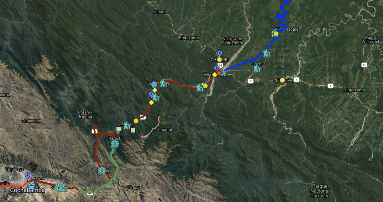
I’ve included some maps here. These are contemporary to the expedition, 1914, 1910 and 1917. The cropped one with an attached legend shows the route/terrain for pretty much the whole trip in Peru-Bolivia, which was initially by train from Molendo, to La Paz then onward to Cochabamba and down to the Amazon. From Garnett’s notes it is clear that the train line from Oruro to Cochabamba ended somewhere near Arque, though they were working on it at the time. This resulted in a ‘horrendous’ trip down the river valley by something along the lines of a stage-coach.

WWI interrupted a lot of commerce, but more important was the invention of synthetic rubber in 1909. Eventually, synthetic rubber destroyed much of the demand for the raw Brazilian rubber, and with it went the business model for these railways. I have seen from Google map aerials that they did a fair bit of tracks the way down to what is now Villa Tunari, a large town straddling the border between the rugged Andes and undulating Amazon rainforest. But it was apparently abandoned before it went into use.

Mapa de la Republica de Bolivia
Bolivia Maps
Bolivia Maps
Bolivia Maps

Related Images:

Filed Under: Collins-Day Expedition, History, Travel

Brief Modern History of the Chapare Region

April 3, 2020 by Lee Leave a Comment

The Chapare is the lowland Amazonian region below the Andean city of Cochabamba in Bolivia. The Collins-Day Expedition of 1915 travelled from Cochabamba to Todos Santos in the Chapare just before modern economic development began. This is a brief excerpt from a paper Institutional Analysis of the Chapare Regional Development Project by Michael Painter, 1990, for USAID.

1940’s Tactical Pilotage Chart for the region between Cochabamba and Todos Santos on the Alto Chapare River

“Modem interest in the Chapare began to rise in the mid-twentieth century. For the preceding seven decades Bolivia’s domestic production had been increasingly organized around supplying tin ore to the international market, a historical pattern engendering social and economic change that culminated in the revolution of 1952 and the assumption of power by the Movimiento Nacionalista Revolucionario (MNR). As it became apparent that the MNR’s agrarian reform, enacted in 1953, was not going to solve the social and economic problems confronting the rural poor of the highland and valley regions, interest grew in exploiting the nation’s tropical lowlands. The success of the revolution had depended On the mobilization of highland peasant producers, but the agrarian reform did not meet the expectations that the mobilization had created. The state hoped that colonization of the tropical lowlands would relieve social pressures in the highlands and valleys, and perhaps provide a stimulus for economic growth there as well.

“Logging was the initial impetus for Chapare settlement, and it remained the most important economic activity until the boom in coca leaf production beginning displaced it in the mid-1970s. Settlement of the Chapare dates from the late 1930s, with the construction of a road from Cochabamba to EI Palmar in 1937. This reached Villa Tunari in 1940, and Todos Santos in 1942. The Chapare River changed course in 1946, however, isolating Todos Santos, and causing a large part of its population to move to the new settlements of San Miguel and Chipiriri. These two areas became major settlement centers for the Chapare after about 1950 (Flores and Blanes 1984:82). The area began to grow more rapidly in the 1960s. The Plan Nacional de Desarrollo for 1962-1971 assigned an important role to lowland settlement, and the Plan Nacional de Colonizacion, which appeared in 1963, designated the Chapare as a priority settlement area. In 1965, the Instituto Nacional de Colonizacion (INC) was established to administer and coordinate settlement activities, including areas for spontaneous and planned settlement; demarcation of individual holdings and formalization of titles; and coordination of international donors, state agencies and nongovernmental organizations involved in providing settlers with infrastructure and social services.

“Construction of the modern highway linking Cochabamba and Villa Tunari also began in 1965. With its completion, in 1972, families from the Andean valleys and highlands of Cochabamba and neighboring departments could establish plots in the tropical valley, and move back and forth between them and land holdings in their home communities. Along this main artery and spreading out on the web of secondary roads and trails being constructed, the population of the Chapare began to grow rapidly, reaching 24,381 people distributed among 54 hamlets by 1967 (Flores and Blanes 1984:82).”

Route of the Collins-Day Expedition 1915 to Chapare River

Related Images:

Filed Under: Collins-Day Expedition, History, Travel

Great Elaenia (Elaenia dayi)

April 2, 2020 by Lee Leave a Comment

Day Roraima Expedition of the American Museum of Natural History (1927- 1928)

Garnett sponsored another collecting expedition to South America in 1927. Mr. Chapman honored his patronage by naming a newly described species in his name.


“In July, 1927, the Museum despatched an expediti onto Mt. Roraima under the patronage of Mr. Lee Garnet Day of New York City and the leadership of Mr. Geo. H. H. Tate of the Museum staff. The expedition returned to New York, February 15, 1928, with 1260 birds secured chiefly by Mr. T. D. Carter of the Museum staff, and also collections of mammals made by Mr. Tate.

“A study of the birds, and particularly of their distribution in connection with that of their allies, has revealed a number of definite facts of exceptional interest but most dificult of interpretation.”
….

American Museum Novitates #341 – February 2nd, 1929

Related Images:

Filed Under: Collins-Day Expedition, History, Travel

Recent Posts

  • 1915 Expedition – Why Boliva?
  • Brief Modern History of the Chapare Region
  • Great Elaenia (Elaenia dayi)

More…..

  • April 2020

Recent Comments

  • lee on 1915 Expedition – Why Boliva?

Picture tag

Abigail Gillespie Acting Animals Archives-Papers Artist Artists Childhood Concord Connie Day (MacLean) Cornwall Day (Nancy) Dogs Don Gillespie Egypt Europe Family - Gillespie Family - LGD Jr Family - LGD Sr Family - Sayles Frank A Sayles Garnett Day Greenwich Henry Mason Day Jr ID Uncertain India Jordan Lee Day Lee Gillespie (Day) Letters Martha's Vineyard Mary Sayles (Ames) Mary West (Gillespie) Mason Day Nancy Day (Sayles) Nancy Lachler (Gillespie) News Clip North America Peter Day Petra Sailing School Tad Gillespie Travel Tunisia Vacation

© 2026 · Family Contexturized · Powered by Imagely